Mount Tire’m, Waterford
Difficulty: Easy
Description: When you arrive in the village of Waterford just past Keoka Lake, turn left onto Plummer Hill Road. The trailhead begins on the left just a hundred yards past the Wilkins Community House. You may have to park on the shoulder of the road. The official name of the trail is Daniel Brown as can be seen by a marker (but Tire’m is well suited if you walk briskly up the initial ascend). This short walk through the woods begins with a steep incline but levels off to a slow ascent to granite ledges from which one can view farms and fields as well as Bear Pond, Long Lake and neighboring peaks. On a clear day you may catch a glimpse of Sebago Lake.
This easy scenic jaunt would combine well with a Fall visit during apple season to the orchard at the crest of the hill on Plummer Hill Road. Ask for the Apple Doc at the Mt. Tire’m Cider Mill. If all goes well they’ll be pressing cider Saturday afternoons (September thru November) starting at 1:00 p.m. See http://www.theappledoc.com/
Directions:
278 WHITES BRIDGE RD, STANDISH going toward WESTERLEA WAY go 2.9 mi
Turn LEFT on US-302 go 12.3 mi
Turn RIGHT on ME-35 go 16.7 mi
Continue on WATERFORD RD(ME-37) go <>
Note: If apple cider and apple sauce and apple juice from the orchard makes your stomach sour, you are not too far from Melby’s Market on Route 35/Valley Road in North Waterford—the home of the Buffalo Burger (five ounces of pure-grass-fed bison served up with homemade onion rings and a bottle of Moxie while your at it!). Oh, and by the way you are only a few short miles from that locally famous yet internatioal road sign at the intersection of Routes 35 and 5. Or if that is a little too far on the wild side of the dietary spectrum, you can double back from the orchard and recline your gentile soul at the Lake House Restaurant in the heart of the Village of Waterford (reservations si vous plait).
Hawk Mountain, Waterford
Difficulty: Easy
Description: The walk up Hawk Mountain is an easy .5 mile ascent on a broad rocky trail that only recently restricted horse, ATV and Jeep traffic. The trailhead is obvious though unmarked and there is a small parking lot on the left side of the road. At the top there is an outcropping of granite that provides a view of the northern portion of Long Lake and more immediately Crystal Lake as well as Bear Pond--to the west of course one sees Mount Washington.
This would be a good spot to visit when the foliage is bright (but I suspect you will be joined by many others) or it might be enjoyed in combination with other stops in and around the friendly town of Harrison; for example, if it is hot then a dip into Crystal Lake or an ice cream across from the Long Lake park; if it is Summer then consider taking in a show at Deertrees Theatre (http://www.deertreestheatre.org/).
Directions:
278 WHITES BRIDGE RD, STANDISH going toward WESTERLEA WAY go 2.9 mi
Turn LEFT on US-302 go 12.3 mi
Turn RIGHT on ME-35 go 15.6 mi
Turn RIGHT on MILL HILL RD go 0.6 mi
Turn RIGHT on HAWK MOUNTAIN RD go 0.6 mi
Arrive at HAWK MOUNTAIN RD, WATERFORD
Thursday, July 10, 2008
Thorncrag Bird Sanctuary, Lewiston

Thorncrag Santuary and Walking Trails
Description: The Stanton Bird Club has been actively engaged in conservation work in the Androscoggin County area for over 80 years. Thorncrag Nature Sanctuary in Lewiston, a 357 acre wildlife preserve, has been the primary focus of that activity through the years. At an elevation of 510 feet, the highest point in the city, this sanctuary sits as a green capstone, a forested oasis surrounded on three sides by urban and suburban development. The "Crag", belonging to the family Thorne in the 1800's, is a familiar and well loved landmark in Lewiston.
Thorncrag encompasses approximately 6 different wildlife habitats: Upland Wetlands, Mixed Forest, Restored Farm Meadows, Vernal Pools, Coniferous Old growth Forest, Built Environment (fireplaces, trails, foundations, walls, amphitheaters, etc.). These six habitats support large, diverse populations of wildlife, trees, and herbaceous plants.
Visitors are encouraged to walk the trails using our 32-page "Self-Guided Nature Trail" interpretive brochure to learn more about the flora and fauna at the sanctuary. The brochure is available for $3.00 (includes postage and handling) from: Stanton Bird Club, P.O. Box 3172., Lewiston, ME 04243. Checks should be payable to: Stanton Bird Club.Brochures are also available for $1 at the Customer Service Desk at Hannaford's Supermarket on Sabattus Street., as well as both the Lewiston and Auburn Libraries.
Directions: DRIVINGFROM I-495 - MAINE TURNPIKE, NORTH & SOUTHTake exit 13 in Lewiston and head west on Rte. 196 (Lisbon Street).Turn right onto East Avenue. (the Promenade Mall will be on your left, Martel School will be on your right). Take East Avenue to the intersection of Sabattus Street (Rte. 126).You will see Rite Aid on the opposite left corner. Turn right onto Sabattus Street and continue until you see Hannaford's Supermarket on the left. Turn left there onto Highland Spring Road at the stone pillar with a Thorncrag sign on top.At the end of Highland Spring Road, turn right, and the Sanctuary parking area will be on your left.
Maine Mountain Division Trail
Maine Mountain Division Trail
Description: Named for the railroad line it parallels, the Maine Mountain Division Trail provides a gently rolling excursion in the rural Sebago Lake Watershed Area, northwest of Portland. The trail extends 4.8 miles from Standish to Windham. Maine's Department of Transportation owns the onward section between South Windham and Fryeburg and has yet to develop it. Trail advocates hope the entire route will someday connect with Portland's well-developed trail network. Start from the western trailhead at Johnson Field in Standish. Pause at the trailhead kiosk to fill out a registration form for use of the parkland within the watershed. From the large parking area, you'll follow a dirt road trafficked in summer by local YMCA campers. The road undulates past stands of mixed conifer and deciduous trees for about a half mile before reaching the trail. Technically, the Mountain Division Trail is a rail-with-trail, although the rail is no longer active. Narrow in places with steep embankments, the rollercoaster like trail sometimes runs level with the tracks and sometimes dips below. The soothing aroma of balsam fir permeates the air, especially near the Presumpscot River. (Note: Description provided by Rails to Trails Conservancy; see Traillink.com)
Description: Named for the railroad line it parallels, the Maine Mountain Division Trail provides a gently rolling excursion in the rural Sebago Lake Watershed Area, northwest of Portland. The trail extends 4.8 miles from Standish to Windham. Maine's Department of Transportation owns the onward section between South Windham and Fryeburg and has yet to develop it. Trail advocates hope the entire route will someday connect with Portland's well-developed trail network. Start from the western trailhead at Johnson Field in Standish. Pause at the trailhead kiosk to fill out a registration form for use of the parkland within the watershed. From the large parking area, you'll follow a dirt road trafficked in summer by local YMCA campers. The road undulates past stands of mixed conifer and deciduous trees for about a half mile before reaching the trail. Technically, the Mountain Division Trail is a rail-with-trail, although the rail is no longer active. Narrow in places with steep embankments, the rollercoaster like trail sometimes runs level with the tracks and sometimes dips below. The soothing aroma of balsam fir permeates the air, especially near the Presumpscot River. (Note: Description provided by Rails to Trails Conservancy; see Traillink.com)
Directions: To reach the trailhead at Johnson Field in Standish, take State Route 35 to its intersection with State Route 114. The parking area is on 35, a quarter mile east of the intersection. You'll find limited roadside parking in Windham.
Sebago Lake Land Reserve
 Sebago Lake Land Reserve
 Description: Sebago Lake Land Reserve is in our neighborhood has allowed for access to walking trails on public land that had not been accessible until a few years ago. The multipurpose trails provide a nearby option to get out for a walk or run. See an overview of the area and trailheads at: http://www.pwd.org/pdf/water_resources/sllrmap.pdf
The Portland Water District announced the grand opening of the Sebago Lake Land Reserve in 2005. While most of the PWD’s land is available to the public, accessing the lake along the Two-Mile No Bodily Contact Zone is still against the law. Fences protect the shoreline land designated as no trespassing, and nine separate permitting kiosks have been erected to guide land users to trails and popular destinations. Any person or group using PWD property will be required to complete a permit form and place it in a designated box.
Permissable uses of the 1700 acres of publicly accessible land include:
1. Hunting 2. Fishing 3. Trapping 4. Environmental Education 5. Hiking/Walking 6. Horseback Riding 7. Cross-Country Skiing 8. Snowshoeing 9. Mountain Biking 10. Snowmobiling on Designated Trails or by Agreement 11. Berry Picking
1. Hunting 2. Fishing 3. Trapping 4. Environmental Education 5. Hiking/Walking 6. Horseback Riding 7. Cross-Country Skiing 8. Snowshoeing 9. Mountain Biking 10. Snowmobiling on Designated Trails or by Agreement 11. Berry Picking
Note: See also Maine Mountain Division Trail as some of the trails overlap
Read about Blessed Pier Giorgio
Bibliography
A Man of the Beattitudes: Pier Giorgio Frassati
Author: Luciana Frassati
Publisher: Ignatius Press, 2001
My Brother Pier Giorgio: His Last Days
Author: Luciana Frassati
Publisher: New Hope Publications, 2002
Blessed Pier Giorgio Frassati: Journey to the Summit
Author: Ana Maria Vazquez and Jennings Dean
Publisher: Pauline Books and Media, 2004
Blessed Pier Giorgio: An Ordinary Christian
Author: Maria Di Lorenzo
Publisher: Pauline Books and Media, 2004
Pier Giorgio Frassati
Translator: H.L. Hughes
Publisher: Burns Oates & Washbourne, LTD, 1933
The Soul of Pier Giorgio Frassati
Author: Robert Claude, S.J.
Publisher: Spiritual Book Association, 1960
The Heart of a Saint: Ten Ways to Grow Closer to God
Author: Bert Ghezzi
Publisher: The Word Among Us Press,2007
Saints for Our Time: New Novenas and Prayers
Author: Barry Michaels
Publisher: Pauline Books and Media, 2207
Also visit the Frassati bookstore
Wednesday, July 9, 2008
Frye Island Walking Trails

Town of Frye Island
Walking Trails
Location: Frye Island off Route 302 in Raymond, Maine
Description: The walking trails are underdeveloped and short; however, the perimeter gravel road is pleasant and quiet. The island is 2.5 miles long and 1.5 wide. I am assuming you could park a car in various places though there is a parking lot at Long Beach causeway from which you could explore the Long Beach area and Azalea Lagoon Trail, walk along Leisure Lane (the road) and Katherine’s Trail. A walk along the western side of the island will bring one past several little secluded beaches (they are numbered e.g. 10, 9, 8, 7 and 6) that look westerly toward Pleasant Mountain and must provide a splendid viewing for a sunset. The biggest of the beaches is #6 at the intersection of North Beach Road and Leisure Lane. The island might be best explored by bike or the beaches enjoyed after a long paddle around Jordan Bay.
Note: The Ferry runs on the half hour and is a short ride to the island. The cost is $5.00 to walk on, $10.00 with a bike and $24.00 a car load (however if you know a resident you can get a ticket for $12.00). In fact the ferry attendant asks who you are going to visit though I assume they would let you on to go sight seeing. Once you are on the island the town office is on your left and they may have island maps. Also on your left as you arrive is a restaurant and general store. See www.fryeisland.com
Directions: See map
1. Start at 278 WHITES BRIDGE RD, STANDISH going toward WESTERLEA WAY go 2.9 mi
2. Turn LEFT on US-302 go 6 mi
3. Turn LEFT on HAWTHORNE RD go 0.4 mi
4. Turn LEFT on CAPE RD go 3.5 mi
5. Turn LEFT on CAPE RD EXT go 1.1 mi
6. Continue on FERRY CROSSING LNDG go 0.1 mi
7. Take FRYE ISLAND FERRY (Check schedules and fares) go 0.4 mi.
8. Arrive at FRYE ISLAND FRY, RAYMOND go <>
Ten Most Popular Hikes in Maine
1 Appalachian Trail: Mount Katahdin
Millinocket, ME
2 Mount Katahdin via the Knife Edge
Millinocket, ME
3 Mount Katahdin - Maine Highpoint
Millinocket, ME
4 Acadia Mountain Trail
Southwest Harbor, ME
5 Acadia National Park Cruise
Bar Harbor, ME
6 Gulf Hagas
Milo, ME
7 Appalachian Trail: White Cap Mountain
Brownville Junction, ME
8 Appalachian Trail: Baldpate Mountain
Bethel, ME
9 Bald Rock Mountain
Camden, ME
10 Appalachian Trail: Mahoosuc Notch
Upton, ME
Millinocket, ME
2 Mount Katahdin via the Knife Edge
Millinocket, ME
3 Mount Katahdin - Maine Highpoint
Millinocket, ME
4 Acadia Mountain Trail
Southwest Harbor, ME
5 Acadia National Park Cruise
Bar Harbor, ME
6 Gulf Hagas
Milo, ME
7 Appalachian Trail: White Cap Mountain
Brownville Junction, ME
8 Appalachian Trail: Baldpate Mountain
Bethel, ME
9 Bald Rock Mountain
Camden, ME
10 Appalachian Trail: Mahoosuc Notch
Upton, ME
Mackworth Island Trail


Mackworth Island Trail, Portland


Description: Mackworth Island is a legislated bird sanctuary approximately 100 acres in size, and is connected to Falmouth by a causeway at the mouth of the Presumpscot River . It is the former home of James Phinney Baxter and of his son, Governor Percival Baxter, and was deeded to the State of Maine in 1943. Currently it is the site of the Baxter School for the Deaf.
The island is open to visitors from dawn to dusk. The perimeter path is maintained by the Maine Bureau of Parks and Lands. A detailed trail map can be borrowed from the guard at the gatehouse near the parking area though there is only one trail and it easy to find and follow. An outhouse is also available in the parking lot. The perimeter walk is level, easy and provides delightful views of the Casco Bay and the city of Porltand. There are several outlets from the trail to little beaches and lookouts all along the way.
Directions: Approach the island from Route 1 just north of the city of Portland off interstate 295. Take a right at the end of the Andrews Avenue Causeway onto what appears to be a residential road. Follow signs to Mackworth Island. Parking is limited to 20 cars. No fee is required.
Gilsland Farm, Maine Audubon Society in Portland


Gilsland Farm Sanctuary and Environmental Center
Difficulty: Easy
Description: The Gilsland Farm was acquired my Maine Audubon through the generosity of the Freeman family. Visitors may walk onto the property from dusk to dawn any day of the week all year long. Maps that detail the walking trails are available at the visitor's center though the dirt and grass trails are apparent and can be followed easily. Trails take you along Presumscot Estuary.
 Directions: The Farm accessible off Route 1 toward Falmouth one exit north of Portland on Interstate 295. The entrance is on the left and located just before you get to the intersection of Route 1 and 88. Parking ample inside the gate or at the gate area when the gate itself is closed. Also google 20 Gilsland Farm Road; Falmouth, Maine 04105
  Note: If you do enter the visitor's center take a look at the exibit on bird eyes painted by Fr. Paul Plante of the Diocese of Portland.
Pleasant Mountain, Fryeburg


Pleasant Mountain, Fryeburg
Southwest Ridge Trail
Difficulty: Moderate; Elevation, 2006 feet
Description: With spectacular views of NH Presidential Range to the west and a rare glimpse of the city of Portland to the east (with an eagle eye on a clear day). Pleasant Mountain on Moose Pond is a great day hike in the neighborhood. Southwest Ridge Trail might be the least used but most scenic way up Pleasant Mountain as it offers an array of views all the way up.
The trail begins with a steady climb through the woods then levels off after a sharp right turn. Watch for this turn and for the cairns that mark the trail. What characterizes this trail is a steady sloping incline offering beautiful views of Pleasant, Long, Beaver, Kezar and other ponds in Denmark and Fryeburg. One follows along granite surfaces much of the time (and in early July the trails is flanked by ripe native blueberries once one emerges from the woods). The trail peaks with vista to the west as one comes across a tepee-like collection of dried trees and branches that has been erected from which point one continues on through a canopied walk through more woods. Look for the beginning of these segment of the trail about a hundred yards beyond the tepee. You may notice a weather warn sign on the left for the fire tower. This gradual descent and ascent intersects the Ledges Trail, which is marked by blue blazes and leads to the summit, where you will find a fire tower.
There are possible variations to this hike up Pleasant Mountain as there are other recently enhanced trails, which might provide loops for the more ambitious, including the Ledges Trail, the Fire Warden Trail and Bald Peak Trail as well as a side trip to The Needles Eye off of the Bald Peak Trail—maps available at http://www.loonecholandtrust.org/.
Note: On the way home consider traveling approximately 3 miles toward Denmark on the Denmark Road (exit left of trailhead) and jumping in the water at a town beach you pass on the left or continuing around the corner to a picnic area also on your left as you take a left on Route 117.
Driving Directions: (approx. 35 miles)
Start at 278 WHITES BRIDGE RD, STANDISH going toward WESTERLEA WAY and go 2.9 miles
Turn LEFT on US-302 go 20.9 miles
Turn LEFT on US-302 go 8.7 miles
Turn LEFT on WILTON WARREN RD
Go 1.0 mile and over a wooden bridge; Fire Warden’s Trail begins on the left in front of large Yellow Victorian house but we are looking for another trailhead.
Continue 1.5 miles to an unmarked intersection—Denmark Road/Lake Road. Turn LEFT.
Travel 1.0 mile passing Mount Pleasant Cemetery and bear LEFT at fork.
Park in a cleared lot at the trailhead located in a clearing across from Fire Lane 78 (Spiked Ridge Drive)
Tuesday, July 8, 2008
Podcast on the Life of Blessed Pier Giorgion Frassati
Paul Camarata of SaintCast.org features the life of Blessed Pier Giorgio Frassati in a weekly podcast that presents the lives of the saints. The link has been provided adn you will have to scroll down until you find the 75th episode dated Tuesday 09 October 2007 where you can download the entire podcast or fast forward to the 21:00 minute and listen in for eleven minutes as you learn about this inspiring young university student who lived an extraordinary Christian live in an ordianary setting much like your own.
http://www.podcastalley.com/podcast_details.php?pod_id=22134&allEpisodes=
Consider listening to other podcasts from SaintCast.org
http://www.podcastalley.com/podcast_details.php?pod_id=22134&allEpisodes=
Consider listening to other podcasts from SaintCast.org
Douglas Mountain, Sebago


Douglas Mountain, Sebago
Distance, 2.3 miles round trip; Elevation, 416 ft; Time, approx. 1.5 hours; Difficulty, Moderate
Trailhead: The trailhead is well marked and there is ample parking.
Description: Douglas Mountain is Sebago provides an aerobic walk up a steep incline though the hike to the summit is relatively short (2.3 miles round trip). This is an easy hike due to short length but a moderate hike due to slope. The path starts out under tall pines and winds over gnarly roots and a pine needle covered forest floor. The walk is well shaded. Can be very slippery when wet or icy. The main trail is a loop and it appears that two short alternative trails can be taken as a variation on the main trail (but do not appear to be well marked enroute). The main trail is marked Nature Trail.
Description: Douglas Mountain is Sebago provides an aerobic walk up a steep incline though the hike to the summit is relatively short (2.3 miles round trip). This is an easy hike due to short length but a moderate hike due to slope. The path starts out under tall pines and winds over gnarly roots and a pine needle covered forest floor. The walk is well shaded. Can be very slippery when wet or icy. The main trail is a loop and it appears that two short alternative trails can be taken as a variation on the main trail (but do not appear to be well marked enroute). The main trail is marked Nature Trail.
The summit provides a panoramic view stretching from Mount Washington to Casco Bay and all the highlights are mapped out on a DeLorme map found on the lookout tower of a unique stone tower dating to 1925. One can enjoy a bird’s eye view of Sebago Lake from the top of Douglas Mountain and look back toward Saint Joseph’s College. You can even practice your Latin (and brag to Reg) when you get to the top by translating the phrase (NON SIBI SED OMNIBUS) etched into a large stone and learn something of the personal philosophy of the former owner of the property.
Notes: The trail is maintained by the town of Sebago and a municipal sign states the trail closing at 6:00 p.m. but there is no gate. A $3.00 donation is requested per carload of people. You pass a ice cream shop on the way back that might only be open seasonal but no doubt worth a stop. Locals say there are plenty of wild blueberries to be picked as a reward for getting to the top (in season of course).
Notes: The trail is maintained by the town of Sebago and a municipal sign states the trail closing at 6:00 p.m. but there is no gate. A $3.00 donation is requested per carload of people. You pass a ice cream shop on the way back that might only be open seasonal but no doubt worth a stop. Locals say there are plenty of wild blueberries to be picked as a reward for getting to the top (in season of course).
A Saint and a Prankster?

Those who think of saints as shy and reclusive people who disdain this life while pining for the next world will be surprised by the figure of Blessed Pier Giorgio Frassati. A practical joker, known as “Robespierre” or the “Terror” by his friends, whom he united in an association called “The Shady Characters”, Frassati was a friend to the poor, in whom he saw Christ. And today’s laity, especially young people, who are looking for a role model, find someone to identify with in this strapping young outdoorsman who combined political activism and work for social justice, who lived his short life “to the full”.
Pier Giorgio Frassati was born in Turin, Italy on April 6, 1901. His mother, Adelaide Ametis, was a painter. His father Alfredo, an agnostic, was the founder and editor-in-chief of the liberal newspaper “La Stampa”, and was influential in Italian politics as a Senator and as well as Ambassador to Germany.
He was educated at home with his sister Luciana, who was one year younger, before attending with her a state school and finally a school run by the Jesuits. There he joined a Marian sodality and the Apostleship of Prayer and obtained permission for daily Communion, a practise which he kept till the end of his life.
Pier Giorgio developed a deep spiritual life which he never hesitated to share with his friends. The Holy Eucharist and the Blessed Virgin were the two poles of his world of prayer. At the age of 17, in 1918, he joined the St. Vincent de Paul Society and dedicated much of his spare time to serving the sick and the needy, caring for orphans and the demobilised servicemen returning from World War I. He decided to become a mining engineer studying at the Royal Polytechnic University of Turin, so he could “serve Christ better among the miners”, as he told a friend.
Although he considered his studies to be his first duty, they did not keep him from social and political activism. In 1919 he joined the Catholic Student Federation and Catholic Action. Participating in a Church-organized demonstration in Rome, he stood up to police violence and rallied the other young people by grabbing the banner which the Royal Guards had knocked out of someone else’s hands. He held it even higher while using the pole to fend off their blows. Like his father he was strongly anti-Fascist and did nothing to hide his political views. On several occasions he was involved in fights, first with anticlerical Reds and later with the Fascists. Independently of his father’s political ideas he became a very active member of the Popular Party which promoted the Catholic Church’s social teaching. He even thought about merging the Catholic Student Federation with the Catholic Workers Organization. “Charity is not enough: we need social reform,” he used to say as he worked for both.
What little he did have, Pier Giorgio gave to help the poor; even using his bus fare for charity and often running home to be on time for meals. The poor who were without God and those who were suffering were his masters; he was literally their servant, and he considered this a privilege. This charity did not involve just giving something to others but giving of himself completely, a self-giving that was nourished by daily Communion with Christ in the Holy Eucharist and by frequent nocturnal adoration, by recitation of the Rosary, by meditation on St. Paul’s “Hymn on Charity” (I Cor 13). He often sacrificed vacations at the Frassati summer home in Pollone because “If everybody leaves Turin, who will take care of the poor?” In 1921 he enthusiastically helped to organize in Ravenna the first congress of the “Pax Romana”, an association which has as its purpose the unification of all Catholic students throughout the world to work together towards world peace.
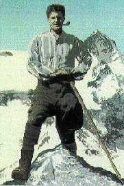
Mountain climbing was one of his favourite sports. These outings, which he organised with his friends -- The Shady Characters -- were also for him occasions for apostolate. He often went to theatres, operas and museums; he loved art and music and could quote whole chunks of the poet Dante. The fiery sermons of Savonarola and the writings of St. Catherine of Siena propelled him into the Third Order of St. Dominic in 1922; he chose the name Girolamo (Jerome), not after the Bible scholar, but rather after his personal hero, the Dominican preacher and reformer of Florence’s Renaissance, Girolamo Savonarola: “I am a fervent admirer of this friar, who died as a saint at the stake,” he wrote to a friend.
Just before receiving his university degree Pier Giorgio contracted poliomyelitis, which doctors later speculated he caught from the sick whom he tended. Neglecting his own health because his grandmother was dying, he died after six days of terrible suffering on July 4, 1925 at the age of 24. His last concern was for the poor. On the eve of his death, with a paralysed hand, he scribbled a message for a friend remembering the injections for Converso, a poor man he had been assisting.
His funeral was a triumph: the streets of the city were lined with a multitude of mourners, unknown to his family -- the poor and the needy whom he had served so unselfishly for seven years. Many of these poor people, in turn, had been surprised to learn that the saintly young man they knew was the heir of the Frassati family.
Bibliographic note: This brief biography of Blessed Pier Giorgio was published on the English page of the Italian website: Assocciazione Pier Giorgio Frassati. Please see http://www.piergiorgiofrassati.org/
Pier Giorgio Frassati was born in Turin, Italy on April 6, 1901. His mother, Adelaide Ametis, was a painter. His father Alfredo, an agnostic, was the founder and editor-in-chief of the liberal newspaper “La Stampa”, and was influential in Italian politics as a Senator and as well as Ambassador to Germany.
He was educated at home with his sister Luciana, who was one year younger, before attending with her a state school and finally a school run by the Jesuits. There he joined a Marian sodality and the Apostleship of Prayer and obtained permission for daily Communion, a practise which he kept till the end of his life.
Pier Giorgio developed a deep spiritual life which he never hesitated to share with his friends. The Holy Eucharist and the Blessed Virgin were the two poles of his world of prayer. At the age of 17, in 1918, he joined the St. Vincent de Paul Society and dedicated much of his spare time to serving the sick and the needy, caring for orphans and the demobilised servicemen returning from World War I. He decided to become a mining engineer studying at the Royal Polytechnic University of Turin, so he could “serve Christ better among the miners”, as he told a friend.
Although he considered his studies to be his first duty, they did not keep him from social and political activism. In 1919 he joined the Catholic Student Federation and Catholic Action. Participating in a Church-organized demonstration in Rome, he stood up to police violence and rallied the other young people by grabbing the banner which the Royal Guards had knocked out of someone else’s hands. He held it even higher while using the pole to fend off their blows. Like his father he was strongly anti-Fascist and did nothing to hide his political views. On several occasions he was involved in fights, first with anticlerical Reds and later with the Fascists. Independently of his father’s political ideas he became a very active member of the Popular Party which promoted the Catholic Church’s social teaching. He even thought about merging the Catholic Student Federation with the Catholic Workers Organization. “Charity is not enough: we need social reform,” he used to say as he worked for both.
What little he did have, Pier Giorgio gave to help the poor; even using his bus fare for charity and often running home to be on time for meals. The poor who were without God and those who were suffering were his masters; he was literally their servant, and he considered this a privilege. This charity did not involve just giving something to others but giving of himself completely, a self-giving that was nourished by daily Communion with Christ in the Holy Eucharist and by frequent nocturnal adoration, by recitation of the Rosary, by meditation on St. Paul’s “Hymn on Charity” (I Cor 13). He often sacrificed vacations at the Frassati summer home in Pollone because “If everybody leaves Turin, who will take care of the poor?” In 1921 he enthusiastically helped to organize in Ravenna the first congress of the “Pax Romana”, an association which has as its purpose the unification of all Catholic students throughout the world to work together towards world peace.
Mountain climbing was one of his favourite sports. These outings, which he organised with his friends -- The Shady Characters -- were also for him occasions for apostolate. He often went to theatres, operas and museums; he loved art and music and could quote whole chunks of the poet Dante. The fiery sermons of Savonarola and the writings of St. Catherine of Siena propelled him into the Third Order of St. Dominic in 1922; he chose the name Girolamo (Jerome), not after the Bible scholar, but rather after his personal hero, the Dominican preacher and reformer of Florence’s Renaissance, Girolamo Savonarola: “I am a fervent admirer of this friar, who died as a saint at the stake,” he wrote to a friend.
Just before receiving his university degree Pier Giorgio contracted poliomyelitis, which doctors later speculated he caught from the sick whom he tended. Neglecting his own health because his grandmother was dying, he died after six days of terrible suffering on July 4, 1925 at the age of 24. His last concern was for the poor. On the eve of his death, with a paralysed hand, he scribbled a message for a friend remembering the injections for Converso, a poor man he had been assisting.
His funeral was a triumph: the streets of the city were lined with a multitude of mourners, unknown to his family -- the poor and the needy whom he had served so unselfishly for seven years. Many of these poor people, in turn, had been surprised to learn that the saintly young man they knew was the heir of the Frassati family.
Bibliographic note: This brief biography of Blessed Pier Giorgio was published on the English page of the Italian website: Assocciazione Pier Giorgio Frassati. Please see http://www.piergiorgiofrassati.org/

Prayer for the Courage to be Great in Honor of Blessed Pier Giorgio
"Heavenly Father, Give me the courage to strive for the highest goals, to flee every temptation to be mediocre. Enable me to aspire to greatness, as Pier Giorgio did, and to open my heart with joy to Your call to holiness. Free me from the fear of failure. I want to be, Lord, firmly and forever united to You. Grant me the graces I ask You through Pier Giorgio's intercession, by the merits of Our Lord Jesus Christ. Amen."
Think Globally! Hike Locally!
Rattlesnake Mountain
14.3 miles away
2 miles
600 ft
Easy hike, close to Portland
Ossipee Mountain, Waterboro Ma
14.9 miles away
3.5 miles
514 ft
None what so ever!
Saco Heath Nature Preserve
15.8 miles away
2.13 miles
Wooden boardwalks thru a classic heath
Douglas Mountain, Sebago
18.4 miles away
2.3 miles
416 ft
Old stone tower at summit, view of sebago lake
Burnt Meadow Mountain
19.3 miles away
2.4 miles
1194 ft
Short hike, great elevation gain, super views of mountains and lake
Chocorua Piper - Weetamoo rock
31.6 miles away
9 miles
2660 ft
Fantastic view of peaked summit and surrounding mountains
South Moat
34.4 miles away
6 miles
2770 ft
Fantastic views
Speckled Mountain, Evans Notch
35.1 miles away
8.2 miles
2400 ft
Spectacular views of Evans Notch and Mt Washington
Sabbaday Falls
35.4 miles away
1 miles
128 ft
Scenic Waterfall, short easy hike for all ages
Kearsarge North
35.6 miles away
6.2 miles
2574 ft
Excellent panoramic views, moderate 6.2 mile RT
Sweeping shoreline views, boats in river
Chocorua via Champney Falls
37.8 miles away
7.6 miles
2250 ft
Easy first mile, steep last mile. Nice views.
Mount Major, Alton Bay
40.8 miles away
3.8 miles
1124 ft
Cliffs, Scenic view of Lake Winnipesaukee
Whiteface and Passaconway
41 miles away
10 miles
3922 ft
Two NH 4k, great views from Whiteface.
Baldface Loop
41.3 miles away
9.8 miles
3600 ft
Cliffs, brook with small falls, great mountain vistas
Red Brook Cascade
45.1 miles away
8.5 miles
1000 ft
Easy trail along river with good swimming
Sawyer Pond
45.3 miles away
3 miles
300 ft
Lovely Pond, streams
Carrigain
46 miles away
10 miles
3300 ft
Exceptional views of most NH peaks
Frankenstein Cliff - Arethusa
48.2 miles away
5 miles
1200 ft
Nice views, 200 foot waterfall
Washington - Summit Cone
50.9 miles away
1.72 miles
919 ft
Panoramic vistas, rocky trails, crazy people
Osceola from East Peak
51 miles away
6.68 miles
2809 ft
Breathtaking vistas of Kancamagus wilderness, steep incline
How Do I Become a Member?

Becoming a member of Saint Joseph's College Frassati Society is easy; all you have to do is contact one of members for information about the next opportunity to join in our mission.
Our mission is equally simple. We want to bring people together in the beauty that surrounds us here at Saint Joseph's College, in the spirit of Blessed Pier Giorgio, who loved to hike with his friends in the mountains around his native Turin, Italy. Pier Giorgio once said:
"Everyday I love the mountains more and more, adn if my studies allowed, I would
spend whole days in the moutains contemplating in that pure air the greatness of
the Creator." (from a letter to a friend returning from Monviso July 26, 1923)
Our day hikes are open to everyone. And no one is required to be a member of the Frassati Society to join us for a hike. We do ask however that members join us in the full mission of the Frassati Society, which is expressed in a personal motto of Blessed Pier Giorgio--Verso l'alto--translated to the top.
As members of SJC Frassati Society we have our sights set on the summits of mountains as well as the highest of all virtues--Christian charity--the love of God and neighbor and so members agree to three conditions for membership; firstly, to offer a prayer daily from the Book of Prayers in Honor of Blessed Pier Giorgio (available from the club); secondly, to be involved in direct charitable service to the poor in imitation of Pier Giorgio; and thirdly, join us in planning a variety of area day hikes for fellow students at Saint Joseph's College, during which we communicate to others something of the person, life and writings of our patron. So then we will want to become acquainted with this Man of the Beattitudes--Pier Giorgio.
Please join us as we go to the top!
Monday, July 7, 2008

Subscribe to:
Posts (Atom)
